Day 2 was spent trekking and swimming the sites around Pagudpud, Ilocos Norte.
Kabigan Falls
A 1.5km trek to the falls, past rice fields, rivers and streams with cold cold water that provide relief to our dirty tired feet, carabaos, forests and "kubos" here and there.
Can't believe that my daughter was able to do it. In fact, she enjoyed it!
Agua Grande
Passed by this place to view the large boulders on the shoreline and the South China Sea. It becomes a natural swimming pool during summer as it naturally fills up with water It is also a popular picnic area amongst locals.
Patapat Viaduct
A very long bridge built on the side of the Cordillera mountain . It was undergoing rehabilitation when we were there. This road links Ilocos to the other provinces up North.
Maira-ira Blue Lagoon
Wow! This place looks paradise from the entrance. Really cool blue water and white sand. The beach, the sea is so clean. No seaweeds, just pure sand and small stones. Too bad though, something keeps on stinging us, so we decided to quit swimming after almost 2 hours.
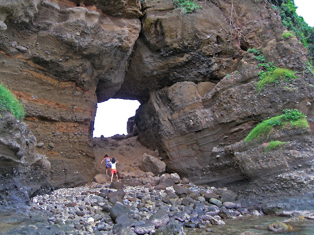
Bantay Abot
This is a rock jutting out of a hill and towards the sea. They say it looks like a turtle from afar, and the a hole at the center of the "head" is the "eye". As per locals, "bantay abot" means the female thing. This is brought about as another rock formation a few meters away from Bantay Abot looks like a male thing. Talk about Filipino green humor!
If you go up the hole, you will be rewarded by another view of the South China Sea.
We left Bantay Abot as it started to rain. We went back to Polaris. The rest
of the group continued swimming. While us? we slept! LOL!
You might want to read:
Naimbag Nga Adlaw Ilocos (Day 1)
Naimbag Nga Adlaw Ilocos (Part 3)
A 1.5km trek to the falls, past rice fields, rivers and streams with cold cold water that provide relief to our dirty tired feet, carabaos, forests and "kubos" here and there.
Can't believe that my daughter was able to do it. In fact, she enjoyed it!
 |
| We trekked... |
 |
| ...we witnessed... |
 |
| ..we crossed streams... |
 |
| ...to see and swim here... |
Passed by this place to view the large boulders on the shoreline and the South China Sea. It becomes a natural swimming pool during summer as it naturally fills up with water It is also a popular picnic area amongst locals.
Patapat Viaduct
A very long bridge built on the side of the Cordillera mountain . It was undergoing rehabilitation when we were there. This road links Ilocos to the other provinces up North.
 |
| Patapat Viaduct |
Maira-ira Blue Lagoon
Wow! This place looks paradise from the entrance. Really cool blue water and white sand. The beach, the sea is so clean. No seaweeds, just pure sand and small stones. Too bad though, something keeps on stinging us, so we decided to quit swimming after almost 2 hours.
 |
| Maira-Ira Blue Lagoon |
 |
| Maira-Ira Blue Lagoon |
This is a rock jutting out of a hill and towards the sea. They say it looks like a turtle from afar, and the a hole at the center of the "head" is the "eye". As per locals, "bantay abot" means the female thing. This is brought about as another rock formation a few meters away from Bantay Abot looks like a male thing. Talk about Filipino green humor!
If you go up the hole, you will be rewarded by another view of the South China Sea.
 |
| Bantay Abot |
 |
| Bantay Abot |
 |
| The beach near Bantay Abot |
You might want to read:
Naimbag Nga Adlaw Ilocos (Day 1)
Naimbag Nga Adlaw Ilocos (Part 3)


No comments:
Post a Comment